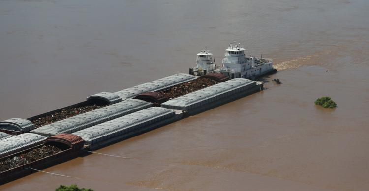
Halted for months by flooding, barge traffic on the McClellan-Kerr Arkansas River Navigation System has resumed on a restricted basis, Tulsa Port of Catoosa Director David Yarbrough said.
“Typically, they are moving 12 to 16 barge tows,” he said Thursday following a board meeting of the City of Tulsa-Rogers County Port Authority. “They are limited to two wide and three deep, so they are limited to six barges.”
Operated by the U.S. Army Corps of Engineers, the navigation system is 445 miles long and runs from the Tulsa Port of Catoosa to the Mississippi River. It supports economic activity across a 12-state region, moving 10.9 million tons of commerce worth $3.5 billion annually, U.S. Sen. Jim Inhofe, R-Okla., said last month.
Spring and summer flooding rendered the channel unsafe for navigation. The heavy rain also resulted in the deposit of tons of silt, necessitating a re-dredging.
When shoaling — the formation of a natural underwater ridge — occurs, the U.S. Coast Guard defines an authorized channel and marks it, Yarbrough said.
“If you get out of that authorized channel, they don’t mark it,” he said. “What happens when you get shoaling like this the channel is blocked, but we’ve found a bypass.
“So while this is blocked, we’ve found a way over here to snag a 2-by-3 tow with a little bit of work. The industry will mark that channel and barge traffic resumes. Until that authorized channel opens, we’ll be restricted, which is limited barge sizes and daylight only.”
The corps has emergency dredgers on the job, Yarbrough said.
“Unfortunately, the entire Mississippi River basin has had flooding, in some cases since January,” he said. “So dredgers are busy everywhere. There is not a lot of dredging availability right now. We’re taking what we can get.
“There still is a lot of work to do. It’s probably still going to take a couple of months.”
Flood Impacts of the River, Updated as of July 25th, 2019:
Drone Footage of the Great Flood of 2019:
This was the first footage before it had crested: https://vimeo.com/339615256/10c1f88036 And this is the one from when it was cresting: https://vimeo.com/341414666/0e94b755d2
| Forecasted Mean Daily Flows, May DataView the PDF here. |